Exposition "Le Doubs en terrain connu?"
Exposition "Le Doubs en terrain connu?"
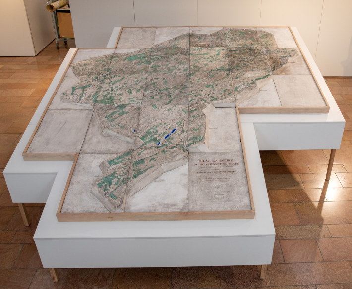
With its 8 m² of rough plaster, the relief plan of the Doubs, produced in 1877, is a real eye-catcher: medium-sized mountains, plateaux and valleys are outlined in three dimensions at the centre of the exhibition. Around it, around a hundred documents - maps, plans, registers, photographs - make up Le Doubs, en terrain connu? illustrating the region and its history.
Divided into four sections - air, water, earth and fire - the exhibition invites visitors to (re)discover the region, particularly from unexpected angles. The earth recalls the creation of the Doubs and the gradual construction of its identity, while the air leads from the sanatorium at Villers-le-Lac to the hymn of the Saugeais and the smell of Morteau and Montbéliard sausages. The water evokes the source of the Doubs, while the fire opens onto the industrial history of the Montbéliard region...
"Our subjects are chosen collectively to showcase the richness of our holdings and surprise the public by telling the story of the department in a different way," explains the Archives' deputy director. Among the major items on display are a map from 1790 recording the creation of the département, and the first register of deliberations of the Conseil général. "I'm proud of the outreach work carried out by the teams at the archives, which enables the treasures of our past and our culture to be passed on to numerous associations and schoolchildren, as was the case for the LIP exhibition," says Monique Choux, County Councillor for Besançon 1.
Dates
Opening periods
From Thursday 27 November 2025 to Friday 3 July 2026
Practical information
Leisure and sciences
Sustainable development
Rates
| MINI | Max | Additional information | |
|---|---|---|---|
| Free of charge | 0 | ||